|
Geographic Information Systems (GIS) Services
Department Overview
Many of our clients performing environmental assessment
and permitting, including regulator agencies and developers of industrial
projects, can make use of Geographic Information Systems (GIS) capabilities
to enhance their projects. GIS increases project understanding,
speeds up data collection and analysis, enables comparison and selection
of alternatives, and improves presentation effectiveness. Project
Managers can reduce budget expenditures using GIS. The industry
trend is toward digital spatial knowledge replacing paper documents
and lower tech solutions. Pinpointing exact locations in project
analysis, project managers can increase productivity and can better
respond to stakeholders inquiries; regulatory agencies can identify
and map sensitive resources; and specialists can utilize geographic
data for specific analysis.
Aspen's expanded GIS Services Department will join
Aspen's internal project teams to provide value added service to
all of our clients. In addition, GIS Services will be available
for independent projects, outsourcing, and consultation.
Selected Project Experience
-
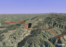
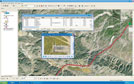
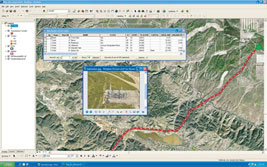
Western Area Power Administration (Western) North Area ROW Environmental Assessment (EA) and Operation and Maintenance (O&M) Plan.
Aspen collected using GPS, aerial imagery, and field surveys biological, cultural, and infrastructure spatial data for 1100 miles of the transmission
and access road right-or-way. All data was verified to have sub-meter horizontal spatial accuracy. In addition, Aspen developed as extensive GIS sensitive resources
database allowing the client to identify resources and mitigation measures anywhere along the project area. The
EA (which mirrors an MND in many respects) and O&M Plan were developed in response to proposed changes in O&M
procedures within Western's North Area ROW and the Transmission Agency of Northern California's (TANC)
California-Oregon Transmission Project ROWs. Collectively these ROWs and associated access roads encompass
more than 1100 miles between Tracy, California, and the Oregon border. These GIS-based conservation measures
were developed to inform Western's line crews of sensitive resource locations, the required Standard Operating
Procedures (SOPs) and conservation measures to implement during O&M activities (access road inventory
and upgrades, relocation of towers, modification of tower footings because of erosion.
-
Western Areas Power Administration Sacramento Voltage Support SEIS and EIR (SVS).
Aspen's GIS department collected field biological data, processed data for spatial analysis and prepared final cartographic products in
support of the project. GIS was utilized to site and analyze route alternatives based on multiple factors on the ground.
In the SEIS and EIR Western proposed to construct a new double-circuit, 230 kV circuit between Western's O'Banion
Substation (Sutter County) and the area just south of Elverta Substation (Sacramento County), and to reconstruct the
existing double-circuit 230 kV/115 kV transmission line between Elverta Substation and Natomas Substation into a
double-circuit 230 kV transmission line. The SEIS and EIR evaluated 17 issue areas including potential impacts to
giant garter snake, Swainson's hawk, and other biological resources, as well as impacts to traffic and transportation
along Highway 99 and Elverta Road. Having completed the project's environmental documentation, Aspen is in the
process of assisting Western in securing permits to begin construction of the SVS Project.
-
California Public Utilities Commission Southern California Edison, Tehachapi Renewable Transmission Project EIR/EIS (TRTP).
Aspen GIS is supporting all EIR/EIS spatial data collection, data analysis, and cartographic production for
the EIR/EIS documentation. Analysts are using the GIS data for alternatives analysis, surveys, GPS field reconnaissance,
and spatial queries for document reports, such as Air Quality, Biological Resources, Land Use, Traffic, Visual
Simulations, and others. The TRTP, proposed by Southern California Edison (SCE), includes a series of new and
upgraded electric transmission lines and substations to deliver renewable energy generated in the Tehachapi
Wind Resource Area (TWRA) located in the upper Mojave Desert. SCE proposes transmission upgrades in Kern County,
Los Angeles County, and San Bernardino County. TRTP would provide the electrical facilities necessary to
integrate levels of new wind generation in excess of 700 megawatts and up to approximately 4500 MW in the TWRA.
-
California Public Utilities Commission -- SDG&E Sunrise Powerlink Project EIR/EIS.
Aspen is supporting the project by providing viewshed analysis for sections of
the proposed and alternative project in the Anza Borrego Desert State Park and Cleveland National
Forest in addition to fire history analysis. The Draft EIR/EIS for Sunrise was completed in January 2008, and the
Final EIR/EIS will be published in July 2008. This is a highly controversial transmission line project proposed to cross
Anza-Borrego Desert State Park in order to improve reliability in San Diego and import renewable power
from the Imperial Valley.
-
California Energy Commission - Peak Workload Support for the Energy Facilities Siting Program and for the Energy Planning Program.
Aspen is assisting the Commission in improving the spatial accuracy of the GIS transmission line corridor database using aerial imagery and field reconnaissance. Technical staff
is reviewing each transmission corridor for location and attribute accuracy and editing the GIS database to reflect these changes.
Aspen has been providing environmental and energy policy services to the Energy Commission since 2000 performing the review of
Applications for Certification (AFC) for all new power plants throughout California. This is Aspen's third 3-year contract,
which has expanded on our environmental services to include energy policy support. It is on-going and involves over 300
Work Authorizations, 65 subcontractors and a total contract value of $23.5 million. It includes the continual support of
power plant siting review, as well as support in preparing a variety of energy planning and policy studies. The energy planning
tasks included support with issues such as: Integrated Energy Policy Report; Environmental Performance Report; Petroleum Infrastructure
Envi ronmental Per formance; water -energy relationship; global climate change; scenario analysis and portfolio analysis; natural
gas assessments; marine resource impingement and entrainment studies at local coastal power plants; border energy supply
and demand; water quality and supply assessments; and other studies. GIS is an integral part of many of our Work Authorizations.
-
County of Santa Barbara Lompoc Wind Energy Project EIR.
Aspen GIS plotted Visual Resources Key Observation Points and identified Wind Turbine
locations in support of the EIR analysis. Under contract to Santa Barbara County, Energy Division, Aspen is
currently managing the preparation of the Final EIR for the proposed Lompoc Wind Energy Project. This
project involves the installation of 60 to 80 wind turbines and associated facilities including an approximately 8
mile 115kV power line, electrical collection and distribution lines, substation, meteorological towers,
onsite access roads and road improvements, communication system, and operation and
maintenance facility. The EIR focuses on the potential impacts associated with project construction and
operation. Operational issues of concern include avian mortality and long-term visual impacts associated with project facilities within a rural environment.
Important Industry Tools We Now Offer
Products
- Cartographic maps: displays, hand-outs, wall-sized,
atlases, presentations, publications, PowerPoint
- Field data collection: Infrastructure, Biological, Cultural
- QA/QC of all data for spatial and tabular accuracy
- Spatial and Imagery data analysis
- GIS training for agency staff
Field Methods
- Planning prior to data collection to ensure usable results
- GPS use: training and field collection for high accuracy
data
- GPS Data Dictionary design and implementation
|
Data Management
- Geographic database design and implementation
- Support for Shapefile, coverage, Geodatabase data models
- CADD to GIS data conversion and interoperability
- User-friendly GIS web page design for high impact
- Interactive map displays for web pages
Documentation for Projects
- Writing GIS sections for project documents
- Selection and management of GIS subcontractors
- Technical and public meeting participation
|
Sample Project Types
- Compare and select alternative sites or Rights-of-Ways
- Evaluate habitat quality
- Reconnaissance & focused surveys
- Determine impacts
- Infrastructure asset management
- Alternative site selection
- Site restoration analysis
- Vegetation management
- Project conservation measures
How You Can Use GIS
- Track projects using real-world coordinates
- Represent field surveys accurately on maps and displays
- Show detail of linear projects accurately on maps and displays
- Present live project demonstrations in meetings
- Demonstrate an empirical "edge" in project documents using
spatial data analysis
- Display data via the web for all project stakeholders
- Update project information accurately and seemlessly when
new data becomes available
- Share your project with all parties involved through one dynamic
system
|