Project Type: Surface Water Drainage
Prado Basin Vegetation Mapping
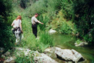
Under a contract with the Corps, Aspen biologists are mapping riparian vegetation
communities on the Santa Ana River below Prado Dam.
Prado Basin, Reach 9, and Norco Bluffs SEIS/EIR. Aspen prepared the Final
Supplemental EIS and Project EIR for the Prado Basin, Reach 9, and Norco Bluffs
components of the Santa Ana River Project in Orange, San Bernardino, and Riverside
Counties. The SEIS/EIR was primarily focused on impacts to biological resources.
It also examined the impacts associated with stabilizing erosion at Norco Bluffs,
changes in inundation levels behind the dam, increased release volumes from Prado
Dam under new operations, and bank stabilization downstream (Reach 9) from the dam.
Aspen also prepared a 404(b)(1) evaluation, prime and unique farmlands evaluation,
and Streambed Alteration Agreement application. During subsequent construction,
Aspen has been monitoring construction activities for compliance with mitigation
and other environmental requirements, and conducting pre-construction surveys for
protected species.
|